Duration: 10 days
Max. Elevation: 4,160m
Highest Camp: 3,680m
Standard: Medium to hard
Best Seasons: October to early November and April to early May
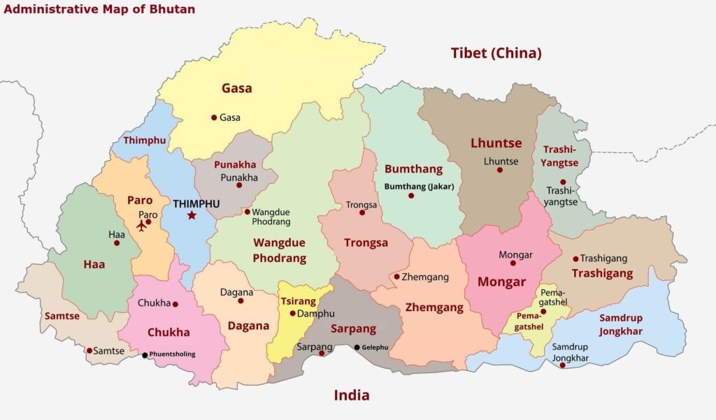
Start: Toktu Zampa (Bumthang)
Finish: Trashiyangtse
SUMMARY
- Most important trade route to eastern Bhutan before roads were constructed.
- Can be seen as an extension of the Snowman Trek ending in Bumthang. (The combination of this two – Snowman and Rodung La – treks, connects the country from the west (Paro) to the far east (Trashiyangtse).)
- Spectacular landscapes, peaks, flora and fauna.
ITINERARY
Day 1: Jakar – Ngang Lhakhang (Distance 20km, six to seven hours, camp altitude 2,800m)
The route takes you around Chamkhar Chhu, a river rich in trout and to Thangbi Lhakhang, a temple built by the first Karma Shamar in the 13th century. You then enter Ngang Yul, or the ‘Swan Land”, at the center of which is Ngang Lhakhang, the “Swan Temple”. It is believed that this part of the valley was first inhabitated by swans who gave their name (Ngang) to the place. A lama called Namkha Samdrup, in his dream had a vision of how to build a temple. Not certain about the location, he shot an arrow in the wild and constructed the Ngang Lhakhang at the place where the arrow landed.
Day 2: Ngang Lhakhang – Ugyenchholing (Camp altitude 2,850m)
Start with a gradual climb to Phephe La Pass (3,353m), an exotically stunning trail and one of the most beautiful forested areas of Bhutan. You will want to stopover at several places and take photographs or loose yourselves in the untainted, pollution free air. Your campsite for the night is Ugyen Choling Palace, which houses one of the most interesting museums of Bhutan.
Day 3: Ugyen Choling – Phokphey (Distance 17km, five to six hours, 920m ascent, camp altitude 3,680m)
It is another walk where you can relish at Nature’s beauty embodied in the flora and fauna that will surround you. The walk takes you through bamboos, hemlock and finally up to an alpine forest. The camp is in a meadow at the head of the valley.
Day 4: Phokphey – Pemi (Distance 20km, six to seven hours, 480m ascent, 1,160m descent, camp altitude 2,950m)
After three hours trekking, you reach Rodung La (4,160m), a pass, after which your journey goes down-hill through a gorge, overlooking some of the mountain valleys. Legend has it that ghosts and yetis are sighted in the region. As you approach your camp for the night, you will see a building made of stone in ruins. The structure was a grain storehouse during the times of the first and second kings.
Day 5: Pemi – Khaine Lakhang (Distance 21km, seven to eight hours, 350m ascent, 1,340m descent, camp altitude 2,010m)
The trail will lead you through the villages of Ungaar, Bulay, Kulaypang and Gomda till you reach Drula village and Khaine Lhakhang (temple). The Lhakhang is one of the oldest temples in the country, built in the mid 7th century by the Tibetan Buddhist King Songtshen Gampo, to subdue demons.
Day 6: Khaine Lakhang – Tangmachu (Distance 18km, six to seven hours, 520m ascent, 810m descent, camp altitude 1,720m)
Your trek starts with a short descend to a stream and a climb back to a basic health unit and community school in Gorsam. Further on, you will pass a Tibetan-style Umling Mani, built by a lama from Tibet, and a chorten (stupa) on Zerim La (Pass, 1,940m). Before you reach the next pass, Tage La (1,760m) you will see Menjabi, a beautiful Bhutanese village with large white houses. South-east of Tage La is Tangmachu Higher Secondary School. There are about 400 students in this school. You could either camp near the school or drive to Lhuentse, the capital of Lhuentse district, with its impressive dzong.
Day 7: Tangmachu – Menji (Distance 16km, four to five hours, 690m ascent, 620m descent, camp altitude 1,830m)
If you have camped at Tangmachu, you will be driven to Kuri Zampa, after which the trek will begin. It is a gradual ascend through paddy fields and villages to Chusa.
Day 8: Menji – Pemi (Distance 20km, five to six hours, 620m ascent, camp altitude 2,450m)
The trek is again uphill through thick forests overlooking mountain views. The camp is under forest shelter at an altitude of 2,400m.
Day 9: Pemi – Taupang (Distance 21km, seven to eight hours, 1,450m ascent, 1,450m descent, camp altitude 2,450m)
Today you will be climbing to Dongla, from where you will have a fascinating view of the mountains. From there, you descend through thick evergreen forests till you reach your campsite.
Day 10: Taupang – Trashi Yangtse (Distance 24km, eight to nine hours, 720m descent)
Though the longest trek of the trip, yet it is not difficult as the walk is a gradual downhill trek. You will be walking along forest covered by chir pine and other hardwood trees and the gigantic oaks of the sub tropical forest zone, until you reach Yangtse.
